Careers
Join a team where innovation meets impact—engineering solutions that shape the future of aerospace, environmental intelligence, and AI.
Work With Purpose. Collaborate With Experts.
- High-Impact Government & Commercial Missions
- Collaborative, Cross-Functional Teams
- Opportunities to Shape Emerging Tech
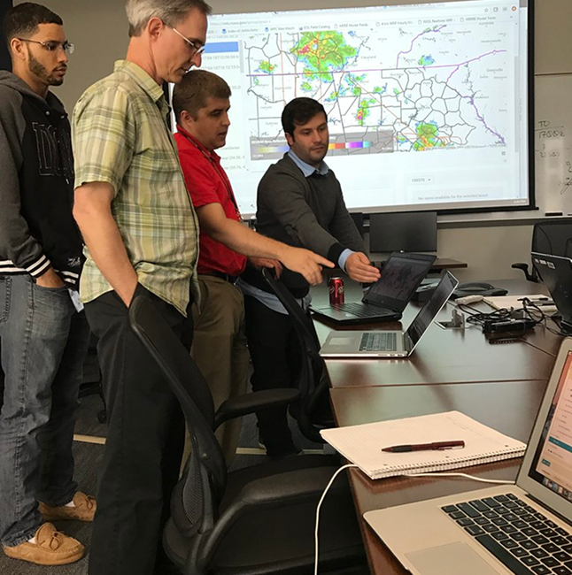
At GeoThinkTank, we believe great work happens when curiosity, expertise, and mission align. Whether you’re a systems engineer, data scientist, or forward-thinking strategist, you’ll join a team that’s shaping the future of aerospace, environmental intelligence, and AI.
A Team Built on Trust and Autonomy
- Flexible Schedules & Remote Options
- Independent Ownership of Projects
- Supportive, Mission-Aligned Culture
We foster a culture of trust and independence—where top-tier professionals are empowered to solve hard problems, lead their own work, and make a real-world impact. If you’re looking for meaningful collaboration without micromanagement, you’ll feel right at home.
Work With Purpose. Collaborate With Experts.
- Diverse Perspectives Driving Solutions
- Blend of Science, Strategy & Engineering
- Culture of Continuous Learning
At the intersection of science, strategy, and software, our team thrives on tackling complex challenges from multiple angles. With diverse minds working together, we build smarter systems and uncover new possibilities every day.
Current Openings
Explore our current opportunities and join a team solving real-world challenges at the intersection of aerospace, AI, and environmental intelligence.
These are some of our open career opportunities:
01.
Imaging Scientist
- Remote / U.S. Based
Join a highly technical, mission-driven team advancing satellite imaging systems for U.S. Government partners. You’ll apply deep EO/IR expertise to support calibration, validation, and performance modeling across complex remote sensing platforms.
This role is ideal for someone with 10+ years of experience in imaging science, strong programming skills, and a passion for precision. You’ll collaborate with scientists, engineers, and mission leads to ensure satellite data is accurate, reliable, and actionable.
02.
Marketing Intern – Nautical Eye App
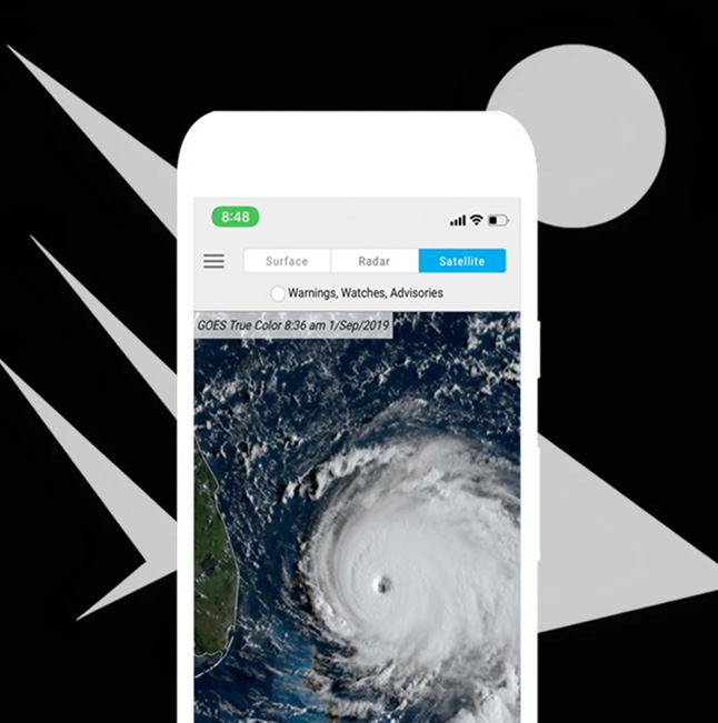
- Remote
We’re seeking a Marketing Intern to help grow awareness of our mobile app, Nautical Eye. This paid internship offers hands-on experience in digital strategy, brand building, and environmental technology marketing.
As part of the team, you’ll support advertising campaigns, content creation, and user engagement strategies. This role is ideal for someone looking to bridge science and storytelling in the digital space.
03.
Meteorology / Data Science Intern
- Remote or Hybrid (based on applicant)
GeoThinkTank is hiring a Data Science Intern to support forecasting and environmental product development. You’ll help analyze remote sensing datasets and contribute to emerging tools in weather intelligence.
Work with imaging scientists and engineers on real-world problems in atmospheric data modeling. Ideal for students or recent grads with interest in meteorology, data analysis, and applied AI.
Our Capabilities
01.
01.
EO/IR Radiometric Calibration & Validation
02.
02.
Integrated Space Systems Engineering
03.
03.
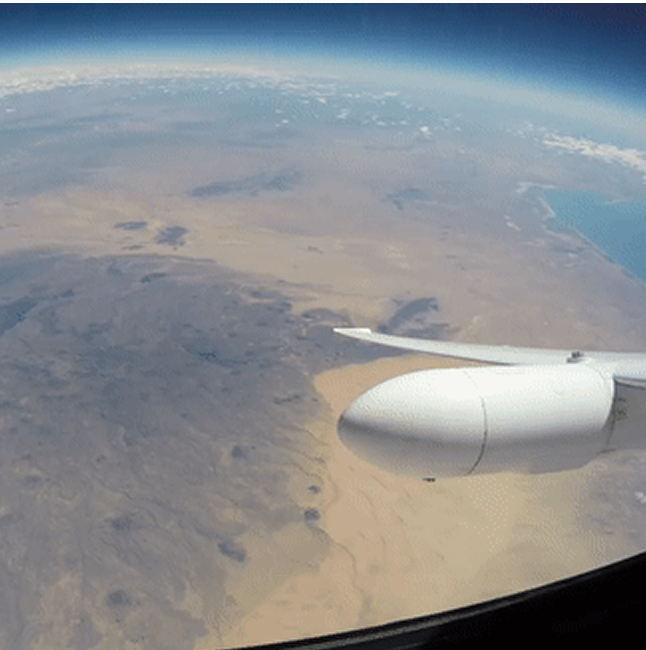
Airborne Systems Integration (Manned & UAS)
04.
04.
Image Chain Analysis
05.
05.
System Design & Performance
Characterization
06.
06.
Modeling & Simulation
07.
07.
Instrument Science
08.
08.
System Optimization
09.
09.
Feasibility Demonstration
10.
10.
Mission Planning & Execution
11.
11.
Data Collection & Analysis
12.
12.
System-of-Systems Architecture
13.
13.
AWS Cloud Computing for Remote Sensing Workflows
14.
14.
Cloud-Based Solutions
01.
01.
Custom Environmental Data Engines
02.
02.
Comprehensive Land, Ocean, Atmosphere & Weather Data Platforms
03.
03.
Predictive Modeling (AI/ML-Driven)
04.
04.
Development of Nautical Eye
5.
5.
EnvIntel.com – Environmental Intelligence API (Coming Soon)
06.
06.
Environmental Intelligence for Government and Commercial Use
07.
07.
Custom Data Engines
08.
08.
Data Access Platforms
09.
09.
Data Engineering and Predictive Modeling (AI/ML-driven)
10.
10.
SnapIntel.com – Instant Alert System
01.
01.
Strategic Systems Consulting
02.
02.
Imaging Science Advisory
03.
03.
Technical Project Management
04.
04.
AI/ML Research & Product Strategy
05.
05.
Data & Workflow Optimization
06.
06.
Commercial Product Development & Launch Strategy
07.
07.
Innovation Roadmapping
08.
08.
Geospatial & Remote Sensing Subject Matter Expertise
09.
09.
Technical Support for RFPs & Government Proposals
10.
10.
Strategic Consulting for Data-Driven Success
11.
11.
Imaging Science End-to-End Advisory
EO/IR Radiometric Calibration & Validation
We provide end-to-end radiometric calibration and validation services for EO/IR systems, trusted by NASA and NOAA. From sensor characterization to post-launch analysis, we ensure your imaging data meets rigorous accuracy and performance standards for mission-critical applications.

Integrated Space Systems Engineering
Our team delivers full-spectrum systems engineering support for complex space-based platforms. We specialize in system architecture, integration, testing, and performance optimization across Earth observation and environmental monitoring missions.
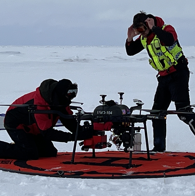
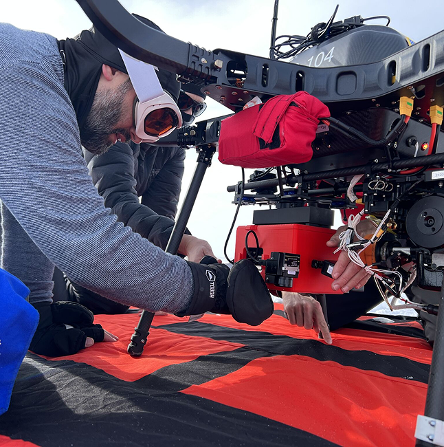
Airborne Systems Integration (Manned & UAS)
We provide design, integration, and field validation for airborne platforms ranging from high-altitude manned aircraft to small UAS. Our expertise includes payload design, calibration, flight planning, and system optimization to ensure successful airborne science missions.
Image Chain Analysis
Our image chain analysis evaluates the full path of sensor data—from photon collection to final imagery. We model and assess performance at every stage to ensure your systems deliver reliable, actionable data in real-world scenarios.
System Design & Performance Characterization
We help clients architect advanced remote sensing systems and measure their performance in real-world environments. Our approach blends modeling, lab testing, and field validation to align design with mission objectives.
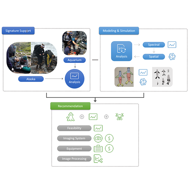
Modeling & Simulation
Our image chain analysis evaluates the full path of sensor data—from photon collection to final imagery. We model and assess performance at every stage to ensure your systems deliver reliable, actionable data in real-world scenarios.
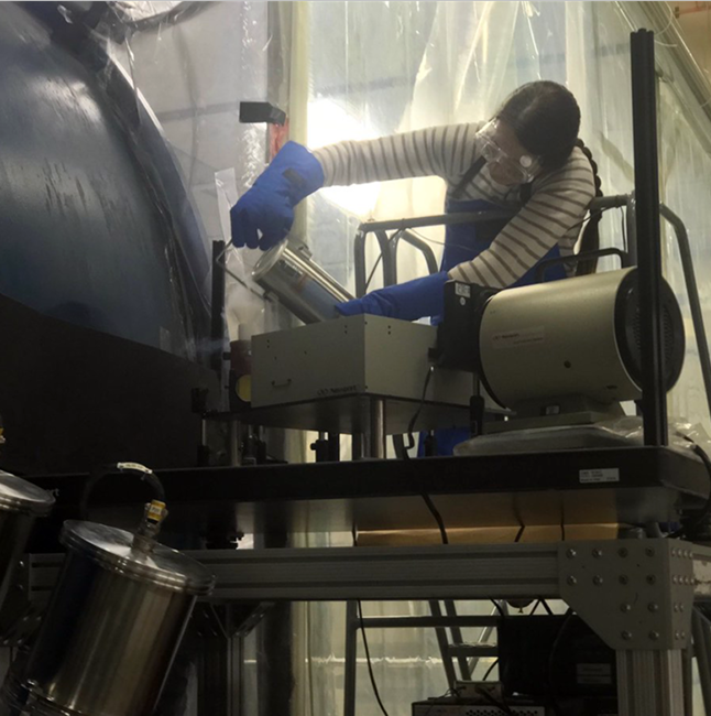
Instrument Science
We design and optimize optical systems for remote sensing platforms, with expertise spanning lenses, mirrors, detectors, and optical coatings. Our work ensures systems meet stringent image quality, resolution, and alignment requirements.
System Optimization
We improve system performance through design refinement, data feedback loops, and operational calibration. Whether improving SNR, reducing distortion, or streamlining architecture, we help clients get the most from their platforms.
Feasibility Demonstration
We evaluate the viability of new systems or technologies through rapid prototyping and field testing. From UAS-mounted sensors to integrated payloads, we help clients validate their concepts in real-world conditions.
Mission Planning & Execution
We support all phases of remote sensing mission planning—from early concept development to in-field execution. Our services include logistics coordination, payload prep, flight planning, and live ops support.
Data Collection & Analysis
We provide scientific data collection and processing services, including sensor operation, data calibration, and post-collection analytics. We extract actionable insights and ensure data meets quality standards for your mission.
System-of-Systems Architecture
We specialize in integrating complex subsystems into cohesive architectures that meet mission-wide objectives. Our approach ensures data flow, interoperability, and scalability across platforms and components.

AWS Cloud Computing for Remote Sensing Workflows
We provide design, integration, and field validation for airborne platforms ranging from high-altitude manned aircraft to small UAS. Our expertise includes payload design, calibration, flight planning, and system optimization to ensure successful airborne science missions.
Cloud-Based Solutions
We deliver custom, cloud-enabled platforms that integrate sensing data, analytics, and visualization for decision-making at scale. These solutions are built to be flexible, secure, and fast.
Custom Environmental Data Engines
We build tailored environmental data engines that deliver fast, reliable access to the data your team needs. These systems are designed to support decision-making in dynamic conditions—built with flexibility, scalability, and usability in mind.

Comprehensive Land, Ocean, Atmosphere & Weather Data Platforms
We develop platforms that provide seamless access to weather, marine, and environmental datasets. Designed for outdoor industries, environmental researchers, and mission planners, our tools bring clarity and speed to critical decisions.

Predictive Modeling (AI/ML-Driven)
Our AI/ML-driven models turn raw environmental data into actionable forecasts and trend insights. Whether it’s predicting weather shifts or optimizing mission readiness, our models are designed for real-world utility and scientific rigor.
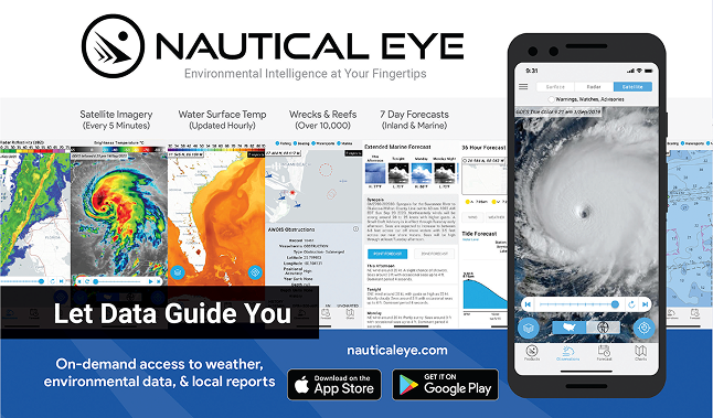
Development of Nautical Eye
Our experience building Nautical Eye—an environmental intelligence app with over 100,000 downloads—demonstrates our capacity for full-cycle product development. From concept and data pipeline design to mobile UX and app store optimization, we created a product that served boaters, anglers, and outdoor users nationwide.
EnvIntel.com – Environmental Intelligence API (Coming Soon)
The EnvIntel API is our flagship backend for on-demand environmental intelligence. Built on AI/ML models, it delivers instant access to weather forecasts, risk scores, and domain-specific environmental metrics.

Environmental Intelligence For Government and Commercial Use
We deploy UAS platforms for advanced environmental monitoring in remote and sensitive ecosystems. Our work has supported NOAA Fisheries and Arctic ice studies—collecting multispectral imagery and delivering analysis for mission-critical science.

Environmental Intelligence for Government and Commercial Use
We translate complex environmental data into strategic intelligence for both public and private sectors. From real-time dashboards to long-term modeling tools, we build solutions that bridge science, policy, and operations.

Custom Data Engines
We develop custom data platforms tailored to the needs of environmental and energy market stakeholders. These systems offer seamless integration of large, diverse datasets into dynamic, actionable insights.

Data Access Platforms
We build secure, user-friendly platforms that provide direct access to curated environmental datasets. These tools are designed to support real-time insight, user customization, and integration with external systems.

Data Engineering and Predictive Modeling (AI/ML-driven)
We transform raw environmental data into usable intelligence through robust data engineering and advanced machine learning. Our team builds scalable pipelines and models that serve real-world applications.

SnapIntel.com – Instant Alert System (Coming Soon)
SnapIntel delivers real-time environmental alerts powered by AI. Designed for users in fast-paced, high-stakes environments, it enables quick responses to critical changes in weather, ocean, or environmental risk.
Strategic Systems Consulting
We provide strategic technical consulting across aerospace, environmental, and defense sectors. From early-stage planning to deployment, we help clients align system design with mission goals and operational needs.

Imaging Science Advisory
Our imaging science experts help clients improve data quality, sensor accuracy, and imaging system performance. We provide technical guidance for research teams, system developers, and program managers.

Technical Project Management
We manage high-complexity technical programs with precision and efficiency. Our leadership of the GOES-R Airborne Science Validation Campaign is just one example of our hands-on, mission-critical coordination.
AI/ML Research & Product Strategy
We help clients explore, design, and launch AI-driven solutions—blending deep technical research with commercial product thinking. From model development to user strategy, we bridge innovation with impact.

Data Reprocessing & Workflow Optimization
We offer advanced data reprocessing services to clean, calibrate, and transform remote sensing datasets for downstream use. Our optimization frameworks help teams reduce bottlenecks and increase throughput.

Commercial Product Development & Launch Strategy
We support the entire lifecycle of scientific or AI-based product development—from concept validation to launch. Our experience spans internal product builds like AI-Thrive.ai to government-to-market transitions.

Innovation Roadmapping for Aerospace, Environmental, and AI Sectors
We help organizations define where to invest, innovate, and adapt. Through structured roadmapping sessions, we guide teams in aligning technology development with long-term mission and market goals.

Geospatial & Remote Sensing Subject Matter Expertise
Our SMEs provide deep, on-demand knowledge for technical teams needing expert input in remote sensing, EO/IR systems, and geospatial analysis. We support R&D, proposal development, and complex project execution.

Technical Support for RFPs & Government Proposals
We help clients craft compelling, technically sound proposals for federal contracts. Our team brings proven experience in responding to RFPs across aerospace, environmental, and data science domains.

Strategic Consulting for Data-Driven Success
We help organizations build better data strategies—combining technical precision with outcome-driven planning. Our consulting spans technical architecture, team design, and end-user delivery.

Imaging Science End-to-End Advisory
From sensor development to data analytics, we provide full-spectrum advisory in imaging science. Our guidance ensures quality, innovation, and mission alignment at every stage.
Entities We Work With


Careers FAQs
We’re a mission-driven team of innovators, scientists, and strategists—building the future of remote sensing, AI, and environmental intelligence. Here’s what potential candidates often ask before applying.
Do you offer remote or hybrid positions?
Yes, many of our roles are fully remote or offer flexible hybrid options, depending on project needs and client requirements.
What types of backgrounds do you look for?
We hire professionals with expertise in systems engineering, remote sensing, imaging science, AI/ML, aerospace, and data strategy. Experience with NASA, NOAA, or federal programs is a plus, but not required.
Are you open to contract or part-time contributors?
Absolutely. We frequently collaborate with contractors, advisors, and part-time experts on mission-critical projects and proposals.
What’s the interview process like?
It typically includes an initial conversation, a technical or strategic deep-dive (depending on the role), and a values-fit discussion. We move quickly and keep communication clear throughout.
Do I need a government clearance to work with you?
Not for most roles—but some projects may require U.S. citizenship or the ability to obtain a clearance. We’ll clarify any requirements during the application process.