Where Strategy Meets Execution
Explore how we’ve helped government agencies and commercial innovators solve complex technical challenges. From EO/IR calibration and performance monitoring, data-driven strategic consulting, to AI empowerment, these projects showcase the depth, rigor, and impact of our work.
"Working with GeoThinkTank was an immense benefit to our research and we greatly appreciated and benefited from their expertise, ingenuity, and problem solving skills."
“GeoThinkTank brought a rare combination of technical depth, operational precision, and mission understanding. Their support elevated our satellite validation efforts.”
KATIE SWEENEY
BIOLOGIST, ALASKA ECOSYSTEM PROGRAM, NOAA FISHERIES
*THE CONTENTS OF THIS MESSAGE ARE MINE AND DO NOT NECESSARILY REFLECT ANY POSITION OF NOAA
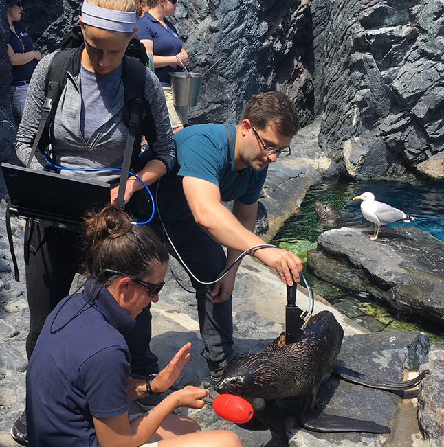
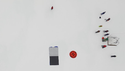
First-Ever Spectral Measurements of NFS and Their Habitats
Advancing the state-of-the-art of Marine Mammal Monitoring in support of NOAA Fisheries
"GeothinkTank LLC was among the best and most creative contractors that I have worked with and I would highly recommend them for UAS operations support and remote sensing data processing."
NOAA/ NESDIS/ STAR
*The contents of this message are mine and
do not necessarily reflect any position of NASA
Revolutionizing Marine Mammal Monitoring with UAS Technology
GeoThinkTank LLC was selected by NOAA Fisheries to develop and deploy an unmanned aerial system (UAS) solution for monitoring northern fur seal (NFS) populations on the remote Pribilof Islands, Alaska. Our involvement, however, extended beyond standard UAS deployment—we proactively identified a critical knowledge gap regarding remote sensing signatures specific to NFS.
To address this gap, GeoThinkTank led a comprehensive measurement campaign, collecting critical hyperspectral data on northern fur seals and their natural environmental backgrounds. Initially, this involved controlled-environment measurements conducted in collaboration with experts from Mystic Aquarium, allowing for precise characterization of seal signatures under controlled conditions.
Armed with these foundational insights, the team then extended data collection efforts, along side NOAA Fisheries, directly into the natural habitats of the NFS in Alaska. GeoThinkTank provided NOAA Fisheries with extensive spectral analysis and end-to-end imaging science expertise, delivering clear, actionable technology recommendations to significantly enhance their mission capabilities.
This groundbreaking initiative led by NOAA Fisheries aimed to transform traditional marine mammal surveys—typically labor-intensive and intrusive—into a safer, more efficient, and minimally invasive operation, leveraging cutting-edge aerial imaging platforms and advanced remote sensing technologies.
Key Contributions:
- Fundamental Science Data Collection Identified and filled a critical scientific knowledge gap through targeted hyperspectral data collection of NFS and environmental signatures.
- Collaborative Expertise Partnered with Mystic Aquarium to validate controlled measurements before executing field deployments in remote Alaska locations.
- Spectral Analysis and Imaging Science Delivered rigorous data analysis and comprehensive imaging science support, enabling NOAA Fisheries to confidently adopt UAS-based monitoring technologies.
- Technology-Driven Mission Enhancement Delivered advanced, data-centric recommendations leveraging UAS platforms, imaging sensors, and spectral analytics to significantly enhance NOAA Fisheries’ mission efficiency, data fidelity, and operational safety—modernizing marine mammal monitoring through scalable, repeatable, and minimally invasive remote sensing solutions.
Threading the Sky to Validate Satellite Lightning Detection
To ensure the accuracy of NOAA’s groundbreaking Geostationary Lightning Mapper (GLM), the GOES-16 Post-Launch Field Campaign brought together NASA pilots, NOAA scientists, and graduate meteorologists to execute lightning-hunting missions from 65,000 feet. Using the ER-2 aircraft and advanced instruments like the Fly’s Eye GLM Simulator (FEGS), the team captured synchronized lightning events across space, air, and ground—enabling “one-to-one” calibration of total lightning data. The results sharpened the GLM’s detection capabilities and set a global benchmark for satellite validation.
Real-Time Weather Intelligence for Wind Energy
Nautical Eye, developed by GeoThinkTank, is a mobile-first environmental intelligence platform designed to support offshore and onshore wind operations. It integrates live weather radar, satellite lightning data, marine conditions, and forecast models into one intuitive interface. Used by agencies like NOAA and NASA, Nautical Eye now offers wind energy companies reliable, on-demand access to mission-critical weather insights—supporting workforce safety, reducing risk, and enabling smarter field decisions from port to platform.
Nautical Eye: Revolutionizing Marine Weather for Anglers
GeoThinkTank launched Nautical Eye as the most advanced mobile weather app designed specifically for fishermen, mariners, and outdoor enthusiasts. Built on decades of fishing knowledge and years of technical innovation supporting NASA and NOAA, Nautical Eye delivers real-time satellite data, point-based forecasts, and marine intelligence directly to your phone. With specialized tools like wreck and reef maps, sea surface temperatures, and lightning alerts, the app empowers anglers to fish smarter and safer across all U.S. waters.
Validating Satellite Precision from the Sky
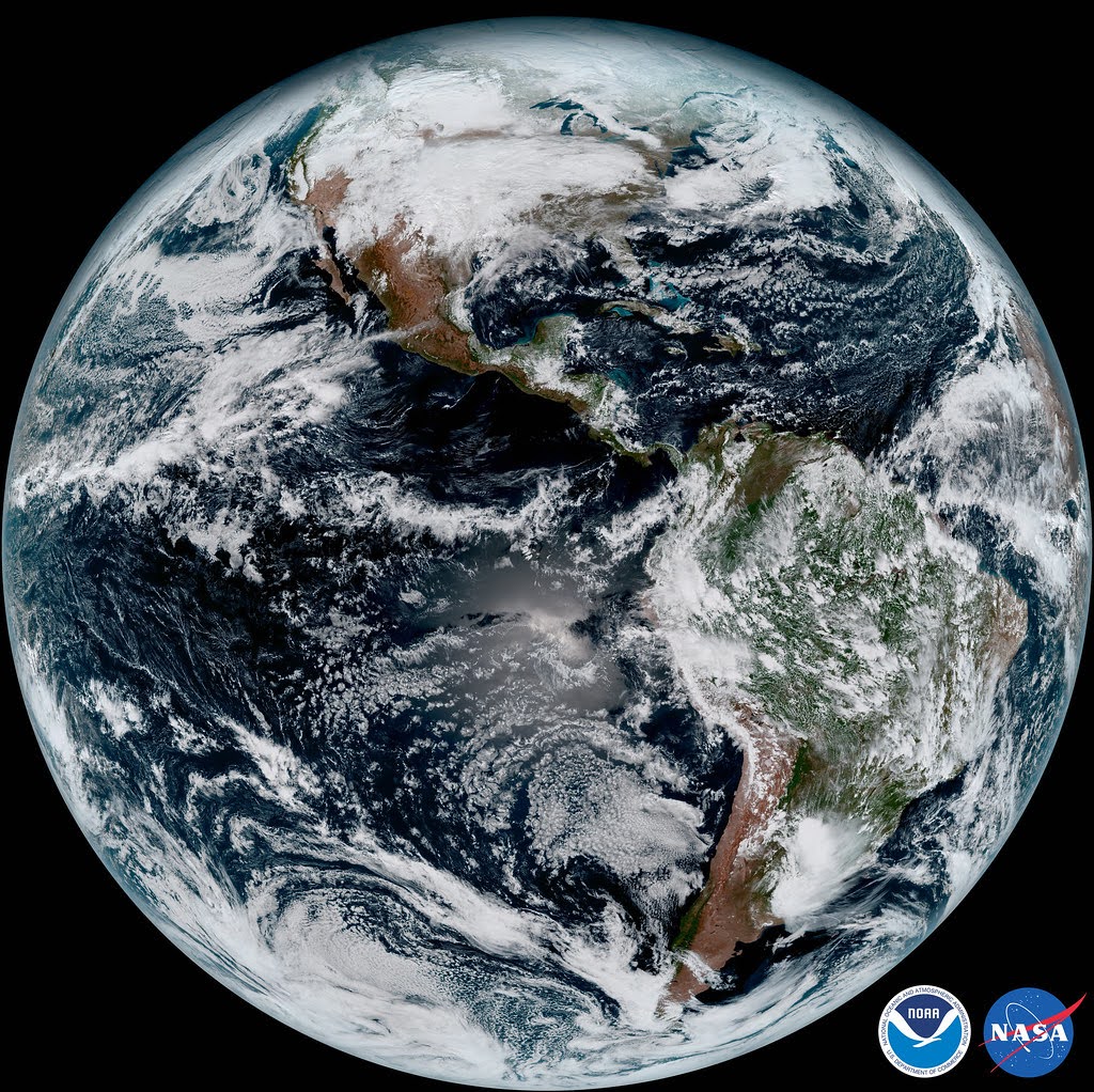
To ensure the accuracy of NOAA’s groundbreaking GOES-16 satellite instruments, the GOES-R team, alongside NASA, launched an extensive airborne field campaign in 2017. Over two months, GeoThinkTank contributed to this multi-agency mission by helping to coordinate high-altitude NASA ER-2 flights and collect multi-domain data from across the United States. Using synchronized inputs from satellites, aircraft, and ground sensors, the campaign focused on validating the Advanced Baseline Imager (ABI) and the Geostationary Lightning Mapper (GLM). This mission played a crucial role in calibrating one of the most advanced Earth-observing systems in history, thereby enhancing weather forecasting and hazard detection across the Western Hemisphere.
Advancing Global Land Monitoring with Landsat 9
GeoThinkTank supported the launch and science readiness of Landsat 9, NASA and USGS’s latest Earth observation satellite in the longest-running continuous land monitoring program in history. With improved radiometric and geometric fidelity, Landsat 9 ensures the continuity of moderate-resolution imagery, which is vital for tracking climate change, land use, carbon cycling, agriculture, and ecosystem health. Our contributions included performance modeling, calibration strategy support, and stakeholder alignment to help sustain the U.S. archive of open-access geospatial data, which is used by researchers and governments worldwide.
Exploring America’s Only Atlantic Marine Monument
In July 2024, Mystic Aquarium and its research partners launched a scientific expedition to the Northeast Canyons and Seamounts Marine National Monument, the only highly protected marine area in the U.S. Atlantic. The mission, led by Dr. Peter Auster and supported by NOAA, Yale, and the U.S. Fish and Wildlife Service, focused on biodiversity research using advanced technologies—including eDNA sampling, baited underwater video cameras, and high-resolution plankton imaging. This collaborative field campaign generated critical insights into apex predator activity, seabird populations, and deep-sea fish behavior, helping shape conservation strategies for vulnerable marine habitats globally.
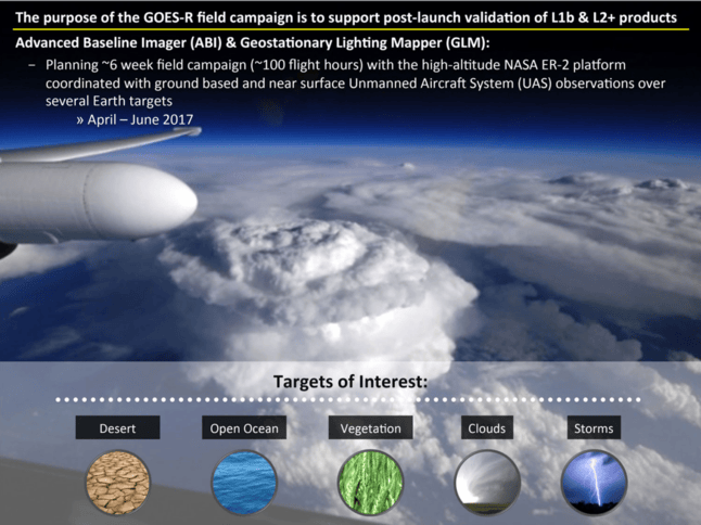
Validating Earth-Viewing Instruments with the GOES-R Field Campaign
To support the post-launch validation of NOAA’s GOES-R Series satellite products, GeoThinkTank led the planning and execution of a comprehensive field campaign integrating high-altitude NASA ER-2 flights, near-surface UAS systems, and ground-based sensors. Conducted from April to June 2017, the campaign targeted a variety of Earth scenes—deserts, open ocean, vegetation, clouds, and storms—to calibrate and validate the Advanced Baseline Imager (ABI) and Geostationary Lightning Mapper (GLM). This end-to-end validation approach pushed the boundaries of remote sensing system performance and helped ensure the accuracy of next-generation satellite data used for environmental monitoring and weather forecasting.
Deep Satellite Ground Processing Expertise to Optimize Products
GeoThinkTank LLC was selected to lead the GOES-R Advanced Baseline Imager (ABI) Level 1b data reprocessing initiative for NOAA and NASA. Our support encompassed comprehensive project management, implementation of cloud-based architectures, and deep subject matter expertise in software engineering (specifically, ground algorithm development and implementation) and radiometric calibration. This initiative was instrumental in helping NOAA/NASA generate an optimized long-term data record for the GOES-R ABI instrument.
Key Contributions:
- Ground Algorithm Optimization Enhanced the performance and accuracy of satellite data processing algorithms to ensure large data reprocessing.
- Cloud-Based Architecture Implementation Leveraged scalable and modern cloud infrastructure to improve processing efficiency and accessibility.
- Data Product Improvements Conducted analysis to enabled the delivery of higher-quality calibration to L1b data products to the user community.
- Mission-Level Reprocessing for Maximum Data Value Conducted full-mission reprocessing to ensure data consistency and value across the instrument’s operational lifetime.

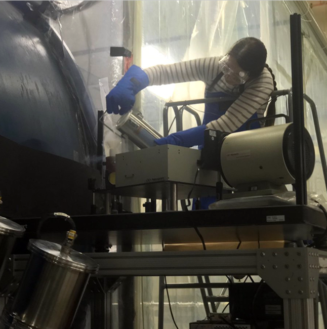
Ensuring Data Quality Through Pre- and Post-Launch Calibration Support
Ensuring Data Quality Through Pre- and Post-Launch Calibration Support GeoThinkTank LLC has played a critical role in supporting several major U.S. Government environmental satellite programs, including GOES-R, NPP & JPSS, Landsat 9, Lucy, GLIMR, and GeoXO. Our team has also provided ongoing technical and consulting support to the NASA Goddard Space Flight Center’s Radiometric Calibration Laboratory.
Our support spans the full mission lifecycle—from pre-launch planning to post-launch performance assurance:
– Pre-Launch: We contribute to test formulation, technical reviews, data analysis, and focused trade studies that are designed to support both independent analysis and in-depth investigations—ensuring test results align with overall instrument performance for mission-critical applications.
– Post-Launch: Our validation capabilities are both extensive and cutting-edge. GeoThinkTank has pioneered novel methods and enhanced established practices to advance the state of the art in post-launch radiometric validation. This ensures the continued data quality and reliability of remote sensing instruments.
Calibrating Satellites with Small Unmanned Systems
GeoThinkTank LLC pioneered the use of small Unmanned Aircraft Systems (UAS) to support the GOES-R airborne science validation field campaign. Our innovation was recognized with the award of U.S. Non-Provisional Patent Application No. 15/423,372 — Directional and Hemispheric Directional Near-Surface Measurements from Unmanned Aircraft Systems.
Combining our deep remote sensing expertise with the flight capabilities of the University of Maryland’s Unmanned Research Operations Center, we advanced the state-of-the-art in post-launch calibration, unlocking new potential for science campaigns in previously inaccessible or challenging environments.
Our ability to align scientific requirements with emerging technologies has earned us continued recognition and support from key stakeholders, including the NOAA/NASA GOES-R Program, NOAA Fisheries, and NOAA/NESDIS/STAR. These efforts demonstrate how scientific innovation can thrive—even in some of Earth’s most extreme conditions, such as the ice fields of Nome, Alaska.
Key Contributions:
- Understanding Application Needs Close collaboration with end users to define clear scientific and operational requirements.
- Technology-to-Application Matching Strategic selection and adaptation of UAS platforms and sensors to meet mission objectives.
- UAS + Sensor Integration and Testing Seamless hardware and software integration followed by rigorous pre-mission and in-field testing.
- Mission Execution and Data Analysis High-quality mission delivery and insightful post-flight data analysis to validate satellite observations.
Commercial Innovation in Action: Nautical Eye – A Weather App Built for the Outdoors
In 2019, GeoThinkTank LLC successfully launched its first commercial product—Nautical Eye, a mobile application designed to empower outdoor enthusiasts with real-time weather intelligence tailored to fishing, boating, and other marine activities. The app was built upon our proprietary geospatial environmental intelligence engine, delivering hyper-local insights that traditional apps failed to offer. Prior to sunsetting the application, Nautical Eye demonstrated the team’s ability to transform advanced environmental data systems into accessible, user-friendly tools for the general public.
This commercial success marked a significant milestone in GeoThinkTank’s history, laying the groundwork for future enterprise-grade platforms coming soon like EnvIntel.com and SnapIntel.com.
Key Contributions:
- Understanding End-User Needs Designed with recreational anglers, boaters, and coastal communities in mind, the app provided intuitive access to mission-critical environmental and weather data.
- Custom Geospatial Intelligence Engine Nautical Eye’s core was powered by a proprietary data engine capable of integrating and analyzing multiple environmental data sources in real time.
- On-Demand Access to Weather & Local Reports Delivered timely weather updates, tide tables, environmental indicators, and user-submitted reports—all from a streamlined mobile interface.
- Market Validation and Product Evolution The app’s success in the consumer market helped validate GeoThinkTank’s technical capabilities in commercial product development. Key lessons from Nautical Eye informed the pivot to scalable B2B and enterprise-grade environmental data solutions.
Trusted By


AI Speaker For
Real-World Innovation
We bring real-world AI insights to everyday innovation.
Recent Press

Navigating the AI Revolution: A Practical Starting Point for Professionals
By GeoThinkTank LLC The AI Moment Is Here—Are You Ready to Lead? Artificial intelligence is no longer a distant promise or emerging trend—it’s a strategic tool already reshaping how organizations operate, compete, and grow. From decisions made in boardrooms to day-to-day workflows, AI is influencing the trajectory of nearly every industry. Yet for many professionals, that shift creates more

Why Real-Time Geospatial Insights Are No Longer Optional for Decision-Makers
In an era defined by rapid change and constant disruption, timely access to accurate data is no longer optional—it’s mission-critical. From sudden weather disruptions and unplanned traffic incidents to rapidly evolving supply chain dynamics, today’s operational landscape is anything but predictable. Leaders need more than just raw data—they need real-time geospatial insights that are fast, contextual, and immediately actionable.

AI for Entrepreneurs & Small Business Owners: Scale Smarter with Confidence
By GeoThinkTank LLC The Competitive Edge Is Shifting—Fast Artificial intelligence is no longer reserved for Fortune 500s and tech startups. It’s quietly (and quickly) transforming how small businesses attract customers, deliver value, and scale operations. But for most entrepreneurs, knowing that AI matters isn’t the issue. The real challenge is knowing how to actually use it—without wasting time, money,